Water
There are numerous ephemeral watercourses over Cooleman Ridge, two reservoirs and two dams within its boundaries. Kathner St Dam is found just inside the northern entrance, and the Old Dam is about 1 km south of the Kathner St entrance on the Bicentennial Nature Trail.
Headwaters
Cooleman Ridge is the headwaters for four creeks.
- The northwest aspect of the ridge drains into Bulgar Creek.
- The southwest aspect of the ridge drains into New Station Creek. Both the above creeks drain into the Murrumbidgee River.
- The northeast aspect of the ridge drains into Weston Creek, and thence the Molonglo River.
- The southeast aspect of the ridge drains into Lake Tuggeranong.
Dams
Kathner St Dam
Kathner St Dam is found just inside the northern entrance.
At the same time as the Group was formed in the early 1990s, there was a drive to utilise Cooleman Ridge for cattle grazing for fuel reduction. The cattle would need a water supply, as would fire fighting vehicles in the event of a bushfire. For these purposes a dam needed to be constructed.
The Group was not happy about cattle trampling native plants and spreading weeds, so they opposed the dam’s construction. However, as a compromise, a barbed wire fence was installed to enclose an area into which cattle could not enter.
Over time, cattle grazing moved to another part of the Ridge where there was another dam, the Old Dam. The Kathner Street dam slowly filled and attracted birds, fish, frogs and yabbies. It became a feature of the Ridge where people could enjoy a peaceful rest on the bench listening to and watching the wildlife.
So, the Group, rather than considering the dam an intrusion, developed a feeling of ownership. It decided to build a platform for the birds. Gösta Lyngå got the task of building it and of swimming out to anchor it in the middle of the dam.

A number of trees took root on the dam wall and were believed to cause water leakage. The problem was solved by the removal of the trees.
In February 2021 a new and more comfortable seat was installed at the dam.
A series of almost 300 photos of the dam between 2003 and 2012 were taken by Pauline and Gösta Lyngå.
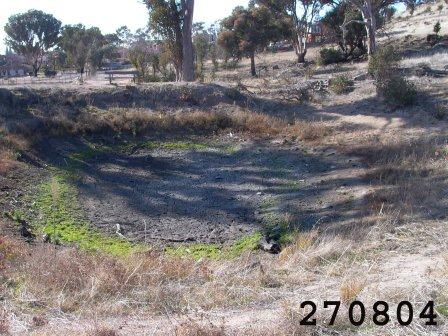
Old Dam
Old Dam is about 1 km south of the Kathner St entrance on the Bicentennial Trail.
This dam was included in the reserve boundaries when the reserve was first established in 1991. At that stage, cattle were still allowed to graze on the ridge in order to reduce fuel load, and this dam was their main source of water.
After the 2003 fires, intermittent cattle herds were grazed regularly along the now-fenced Bicentennial Nature Trail, and they continued to affect the dam with their hooves and manure. In 2018 the Parks and Conservation Service erected a fence around the dam to prevent cattle access, and it is now showing signs of recovery. Some planting has been done around the perimeter to provide habitat for birds and animals, and a new seat provides comfortable viewing of dam activities.

Reservoirs
Icon Water operates and maintains 48 reservoir sites in the four water distribution zones around Canberra. Two of these reservoirs are on the Ridge. One is the octagonal structure close to Darrell Place and the other is the round one up the hill from Guinness Place. Within the latter site is an Optus mobile telephone tower. The octagonal structure supplies mainly Rivett and the round one covers Chapman and upper areas of Fisher.
They use a gravity feed system of distribution. Both reservoirs are supplied from the water treatment plant on Mt Stromlo. Some 25 pump stations distribute water around Canberra with most of it going through the Mt Stromlo facility which does a little ‘polishing’ or removal of microbiological organisms that may be present. Also there is some chlorination of water to remove contaminants that may be taken up in the journey from water treatment plant to householders’ taps.
People may recall the water supply issues resulting from the de-roofing of the round reservoir and subsequent contamination of its contents during the January 2003 fire. Chapman and Fisher residents were advised not to drink the water. ACTEW supplied bottled water in the interim. Also, water supply from the octagonal reservoir was affected because power was down. A generator was brought in to maintain supply.
Water Watch
Members of the group test the water quality of the Kathner and Old dams on a monthly basis, and sends the results in to the Waterwatch database.
This data reflects the health of the catchment area, which can be affected by changes in vegetation, erosion, animal activity or weather.
Erosion
Cooleman Ridge suffers from little erosion except on the main vehicle tracks, some of which are quite steep and therefore are prone to heavy water run-off. These tracks are repaired when funding allows.
In 2007 a huge deluge on the Ridge flooded some of the houses in Chapman. As a result, the cut-drain was installed so that the water is safely diverted in the future.
Rainfall
The table below shows the rainfall (mms) recorded near the Old Dam.
| Year | Jan | Feb | Mar | April | May | Jun | Jul | Aug | Sept | Oct | Nov | Dec | Total |
|---|---|---|---|---|---|---|---|---|---|---|---|---|---|
| 19 | 50* | 44* | 73 | 21 | 25 | 16 | 3 | 20 | 37 | 13 | 16 | 2 | 320 |
| 20 | 19 | 88 | 113 | 92 | 13 | 52 | 38 | 123 | 54 | 145 | 64 | 39 | 840 |
| 21 | 93 | 87 | 139 | 2 | 56 | 105 |
*Approximate reading based on figures in Rivett